Residents across the east are being asked to brace yet again for both storm and fire risk with winds up to 80km per hour expected and a total fire ban in place for the central district on Thursday 22 February.
A little over a week since the storm that lashed the outer east, emergency service organisations are not expecting the weather to be as severe as last week but are warning people to be prepared for all conditions.
Bureau of Meteorology emergency services meteorologist Kevin Parkyn said he would expect winds of 60 to 80 kilometres per hour and isolated thunderstorms to pass late in the day.
“We won’t be seeing the same wind strengths that we saw last week. We won’t be seeing the same prolific thunderstorm activity that lashed the state last Tuesday,” he said.
“If we cast our eyes back to last Tuesday, we had a number of wind gusts of 100 to 130 kilometres an hour and looking at the destruction we saw there were likely gusts well in excess of that.”
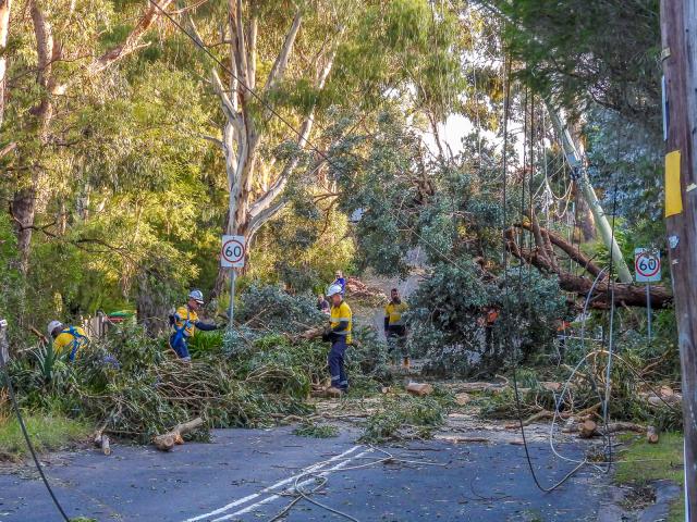
Victoria State Emergency Service (VICSES) chief operations officer Tim Wiebusch confirmed that since Tuesday 13 February units had received over 6000 calls for assistance.
“We’ve now seen over 1000 requests for assistance in the Monash council area. We’ve seen, up around Emerald and Cockatoo and Gembrook, almost 500 requests for assistance,” he said.
“I can now report that there have been 37 homes that have been deemed uninhabitable as a result of the storms from last Tuesday and the devastating impact that they’ve had across many communities.”
Mr Wiebusch reiterated that the storms expected tomorrow would not be as “ferocious” as those seen last week but the risk of trees falling is still high.
“With those storms there is the risk of further tree branches and trees coming down that have perhaps been dislodged by the previous storm event and also the risk of debris on roads.
“So we’re alerting the community tomorrow, if you don’t need to go into some of those previously storm damaged areas like the Dandenong ranges or the South Gippsland area. We would encourage you not to go there.”
People have also been advised to avoid walking tracks where trees or branches may fall, as well as not to park cars under trees where possible.
Mr Wiebusch said isolated incidents of power outages should be expected and people “need to be ready for that eventuality”.
The forecast will also bring rain but Mr Parkyn said it won’t “pack as much punch” with an estimate one to 10 millimetres predicted to fall directly under the thunderstorm.
Perhaps more concerning is the risk of dry lightning, particularly on a “bad fire weather day” with temperatures forecast to reach 38 degrees in Melbourne, 43 degrees in Mildura and 40 in Geelong.
“Dry lightning we know can start fires fanned by the strong northwesterly winds. So that’s something we’ll be paying particularly close attention to,” he said.
CFA deputy chief officer Rohan Luke said the extreme weather conditions for tomorrow come with a warning for the community to be vigilant, review their fire plan and prepare early.
“We are expecting to see a challenging day, a very dynamic day that will put pressure on our communities and our fire services,” he said.
“[People should] ensure they have appropriate access to messaging through ABC and through the VicEmergency app.
“We ask people to have multiple sources of information and not necessarily rely on being advised or warned of what to do.”
Additional strike teams and overnight crews have been put on alert, particularly for the western part of the state which saw fires in the Grampians region last week.
A total fire ban means no fires can be lit, no fires are to remain alight and the use of farm, welding, chainsaw and road machinery should be avoided.
“I’d ask the community to ensure they support us, support our fire services that have been really busy over the last week or so to prevent new starts, and to be really cautious about any fire activity or anything that could introduce fire into our landscape,” Mr Luke said.
The cool change is predicted to reach the south west coast around midday, heading east to the suburbs around 6pm to 7pm.
Mr Parkyn said temperatures may drop about 15 degrees in 15 minutes out on the coast as the southwesterly passes and winds may remain strong during the afternoon and evening.
“In terms of the outlook, this is certainly a fire danger spike day. We’re not expecting another extreme fire danger day.
“We’re looking at much milder conditions on Friday [with] southwesterly airflow but still quite breezy, and then settle weather over the weekend into early next week.”