
By Mikayla van Loon
Heavy rainfall lashed the Yarra Ranges causing unusual early January flash flooding of local streets, roads and floodplains.
In some parts of the shire, rain gauges collected upwards of 100mm in 24 hours, equating to around one sixth of Melbourne’s yearly rainfall average.
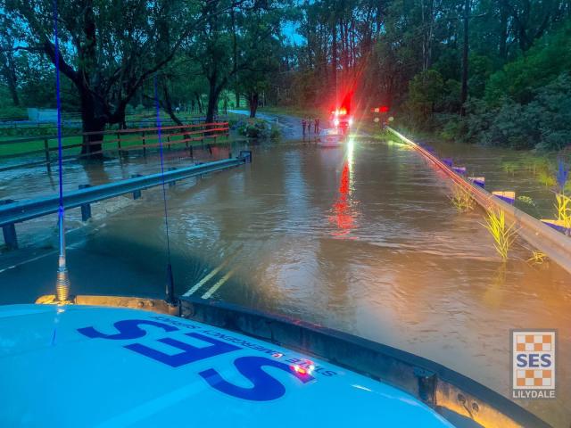
Lilydale SES were kept busy as they responded to 76 calls for assistance from the night of Sunday 7 January, with two water rescues required.
“We certainly had a very busy period with 76 requests for assistance in total, the majority of them over the course of Sunday evening into Monday with a couple of local rain gauges recording up to 150 mils of rain in and around the Lilydale/Coldstream area,” unit controller Shaun Caulfield said.
“That varied slightly between some of the locations but there was certainly, in that area, well over 100 mils of rain in 24 hours.
“That significant amount in such a short period of time you end up with the issue of overwhelmed drainage systems and alike leading to a lot of the flash flooding that we saw.”
Bureau of Meteorology senior meteorologist Christie Johnson confirmed this
“Our rain gauge at Lillydale Lake had 99.4, Mount Evelyn had 97.4, Coldstream had 86.4; a lot of places being over 100 millimetres and some of that did fall in reasonably short periods of time with thunderstorms,” Ms Johnson said.
Ms Johnson said there was a record at The Bureau’s site in Coldstream, which has been open for 31 years, with its highest average daily rainfall reaching 76.2 millimetres to 9am on Monday.
“There were quite a lot of records [across Victoria]. It would be unusual for us to see multiple record breaking rainfalls events in the one month,” she said.
“We’re probably not expecting anything of the same order as what we saw in the last 24 hours or 48 hours.”
While the “usual suspects” like Melba Highway coming into Yarra Glen, as well as the racecourse, flooded, Mr Caulfield said what made it unusual this time was water pooled on the highway between Macintyre Lane and St Huberts Road in Yering.
“We also saw it in some less common areas such as on Swansea Road outside Lillydale Lake. There were some quite isolated heavy falls in that south area of Mount Evelyn,” he said.
“We saw a lot of water running, literally running down Hereford Road. There was probably 30 centimetre deep water flowing down the full width of Hereford Road which obviously comes down and goes around the corner trying to get to Lillydale Lake.”
This was the location of one of the required rescues, with the other occurring in Wandin.
“Someone had driven into that water and the stretch of road that was underwater was probably about three to 400 metres long, stretching from the roundabout at Swansea Road and Anderson Street, all the way past the front of the lake,” Mr Caulfield said.
“The gentleman’s small car didn’t make it through the water and he stopped in the middle and was floating along in the water. Our team we’re on scene within about five minutes of the call coming in and we’re able to get him safely out of his car.”
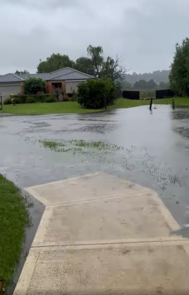
Residents in and around Bristol Crescent confirmed major flooding occurred yet again despite drainage works, with one resident saying “it was bad, it flooded my property and neighbours again”.
Bristol Crescent and surrounding streets like Valencia Road were severely impacted in October 2022, with river-like water flowing through backyards and pushing down fences.
The streets of Morokai Grove and Nimblefoot Way were also yet again inundated by flooding, with photos posted to the Lilydale Flood Watch group page on Facebook showing the extent of the high levels of water.
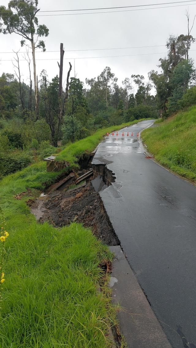
A section of the road on Charles Road in Lilydale also fell away in a small landslip. Other roads impacted included Coldstream West Road in Coldstream, Paynes Road in Chirnside Park and Hardy Street in Lilydale.
Mr Caulfield said while Lilydale SES’s coverage area was impacted quite heavily, regions across the state experienced much worse.
“We’ve seen impacts recede more quickly. So there’s still a lot of water standing around but we’re not seeing the impact as much,” he said.
“We had a few calls from people who have had repeated exposure to this flash flooding and obviously they become quite concerned but the water levels were no higher than a couple of the more recent events such as October ‘22 and June ‘21 events.
“So whilst they were concerned they weren’t necessarily directly impacted this time because although we had a lot of rain in a very short period of time it wasn’t sustained to the point where it built up over a day or so.
“Luckily we didn’t really have any real wind with this event either with the ground being so wet, had we had wind as well we could have seen a lot more tree jobs, we only had a couple of trees and roof related jobs.
“The majority were flooding or water coming into the house or through overwhelmed gutters and drainage which unfortunately does happen because none of the drainage systems are really set up for 100 mils in a few hours.”
VicSES had received a total of 1717 requests for assistance as of Tuesday morning (9 January), with a total of 49 water rescues.
While a flood warning was still in place for the Yarra River downstream to Coldstream on Tuesday, with it expected to peak that night, Mr Caulfield said “it should peak at under the moderate flood level”.
Melba Highway was reopened to drivers on Tuesday as well.
The outer east can expect to see average weather conditions for the remainder of summer, according to Ms Johnson.
“In terms of looking forward for the rest of summer, long term climate outlooks for the Melbourne and the Dandenongs area are not showing a strong signal towards either wet or dry, but average conditions,” she said.
“Part of the reason we’ve been seeing these sort of thunderstorm outbreaks is because we have very warm sea surface temperatures off the east coast at the moment, so anytime we get easterly winds, those are bringing very humid tropical air over Victoria, which is why we’re getting thunderstorms that are probably more reminiscent of what you get in Queensland with that tropical air.”


